
EWP: 2010 Spring Experiment Summary
Working Hypotheses
- Operational meteorologists can provide valuable feedback of experimental severe weather warning decision-making products and displays which are being designed and tested as candidates for operations.
- Operational meteorologists get exposed to the latest research and development ideas when immersed in a collaborative environment, and can carry that information back with them to share with their peers in the operational world.
- Researchers and technology specialists can gain a better understanding of the operational requirements of the severe weather warning forecaster if they work closely with them during real-time warning exercises in a testbed setting.
Specific Objectives
Research Perspective
- To work with GOES-R Proving Ground and collaborators in the development and testing of baseline and potential future satellite products.
- To work with NSSL and NWS-MDL scientists on the development of Multiple-Radar / Multiple-Sensor (MRMS) severe weather applications.
- To work with NSSL scientists on the development of scanning strategies for the Phased-Array Radar (PAR) and understanding how faster scanning rates affect warning decision making.
- To work with NSSL, and Collaborative Adaptive Sensing of the Atmosphere (CASA) scientists on the development of algorithms and scanning strategies for low-cost gap-filling collaborative radar networks and how they affect decision making of NWS warring forecasters and emergency management and weather spotter partners.
- To work with Warning Decision Training Branch trainers on the development of best practices for the use of experimental research products designed for transition to operations.
Operational Perspective
- To evaluate the operational utility of experimental applications intended for the GOES-R satellite platform, including convective initiation products, overshooting tops products, and total lightning data, prior to the launch of the observing platform.
- To identify best practices for using experimental products in nowcast and warning decision making and identifying appropriate display strategies within AWIPS.
- Evaluate operational utility of Phased Array Radar (PAR) technology and the potential operational impacts of higher temporal resolution data on the warning decision process. What additional warning lead time might be gained?
- Evaluate operational utility of Collaborative Adaptive Sensing of the Atmosphere (CASA) dense radar network data and low-level, real time wind products and forecasts derived from those data, for severe weather decision-making through real time warning situations and structured experiments with archived data.
- Evaluate the operational utility of multiple-radar/multiple-sensor (MRMS) severe weather algorithms in supporting NWS operations. We would like our participants to provide feedback on the ability of these applications to enhance traditional base-radar data analysis and suggest improvements or new MRMS products to aid warning decision making.
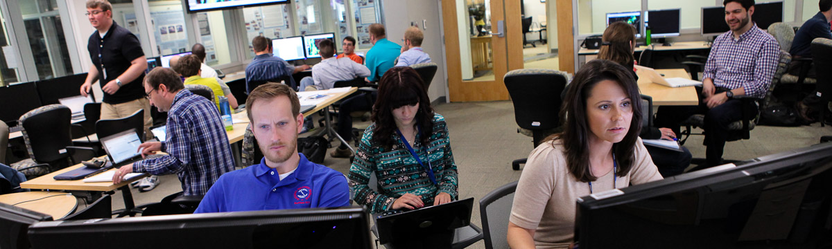
Participants
- NWS WFO: 33
- NWS RHQ: 2
- FAATC: 1
- NWS WDTB: 1
- Academia: 17
Preliminary Results
- PAR
- Forecasters benefited knowing that features in velocity have temporal continuity in the rapidly-updating scans, which were not as dramatic in 4-5 min WSR-88D scans.
- Forecasters were challenged to keep up with multiple storms with new data coming every 30 seconds.
- CASA
- Was very instrumental in detecting certain storm features that would have been missed by traditional WSR-88D, including several Quasi-Linear Convective System (QLCS) vortices that led to wind damage, and an anticyclonic tornado from an anticyclonic supercell.
- MRMS
- MRMS grids greatly augmented and raised the confidence of warning decisions by allowing the algorithms to rapidly perform certain tasks, thus permitting the human forecaster to focus on the more-difficult warning decisions.
- The forecasters also indicated that the hail swath and rotation tracks products significantly aided in the positioning of their storm-based warning polygons such that hazard threat areas were less-likely to exit the warning polygon areas and move into unwarned locations. This leads to reduced false alarm area and fewer missed portions of storm hazard areas
- GOES-R
- PGLM data helped increase forecaster confidence to warn or not to warn, especially with pulse storms or storms right at severe limits, and was indicative of updraft fluctuations. PGLM data is particularly useful when blended with other radar and sensor products. One limitation is that the data are sometimes too coarse to pick out individual updrafts.
- The UWCI products were useful to add lead time. However, they were somewhat conservative in their detections, and had issues under thick cirrus.
- The UAH CI products were much more liberal in their detections, and it was difficult to determine which detections would actually lead to convection.
- Overshooting tops product generally indicated the most severest of the storms, but radar data had usually already indicated that ahead of time.
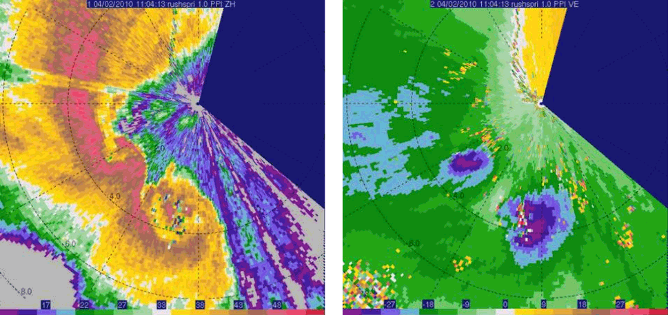
KRSP CASA reflectivity (LEFT) and velocity (RIGHT) of two Quasi-Linear Convective System (QLCS) vortices at 1104 UTC 2 April 2010 near Rush Springs, OK. Data collected at 1.0° elevation angle. From Mahale et al., 2010. [+]
KRSP CASA reflectivity (LEFT) and velocity (RIGHT) of two Quasi-Linear Convective System (QLCS) vortices at 1104 UTC 2 April 2010 near Rush Springs, OK. Data collected at 1.0° elevation angle. From Mahale et al., 2010.
Payoff
- The MRMS system was officially recognized as a NWS Line Office Transition Project, and efforts are underway to install the first MRMS operational system at NCEP. The new operational system, which supports warning and forecast operations for severe weather, aviation, and numerical weather prediction, will be known as the Rapidly Updating Analysis (RUA) system.
- During the interim, some of the MRMS severe weather products have been made available in an experimental data stream to the Storm Prediction Center, to all NWS forecast offices in Southern, Central, and Eastern Region, to be viewable in their operational AWIPS workstations, and via Google Maps.
- The NSSL On-Demand Severe Weather Verification System, by which government users, academia, and their non-commercial partners can place one-time requests for MRMS hail swath and rotation track data to aid in severe weather verification and disaster first response, continued to gain popularity.
- In order to quantify the improvements in warning accuracy provided by the experimental MRMS data, a geospatial verification system for severe weather warnings was developed.
Related Publications
- Gurka, J. J., S. J. Goodman, T. J. Schmit, C. W. Siewert, M. DeMaria, and G. T. Stano, 2010: Warning related satellite products to be demonstrated in the GOES-R proving ground. Extended Abstracts, 25th Conf. on Severe Local Storms, Denver, CO, Amer. Meteor. Soc., 7B.6.
- Kuhlman, K. M., D. M. Kingfield, G. T. Stano, E. C. Bruning, B. C. Baranowski, C. W. Siewert, 2010: Use and Evaluation of Lightning Data within the 2010 Experimental Warning Program and GOES-R Proving Ground. Extended Abstracts, 25th Conference on Severe Local Storms, Denver, CO, USA, American Meteorological Society, P4.2.
- Kuhlman, K. M., T. M. Smith, J. Gao, K. L. Manross, K. L. Ortega, G. J. Stumpf, 2012: Real-time 3DVAR analyses and forecaster evaluation during the 2011 Hazardous Weather Testbed Experimental Warning Program. Extended Abstracts, 16th IOAS-AOLS, New Orleans, LA, USA, AMS, 3.6.
- Mahale, V. N., J. Brotzge and H. B. Bluestein, 2010: The detection of low-level misovortices embedded within a quasi-linear thunderstorm complex on 2 April 2010 by CASA radar. Extended Abstracts, 25th Conference on Severe Local Storms, Denver, CO, USA, American Meteorological Society, 4A.5.
- Siewert, C. W., K. M. Kuhlman, B. Reed, D. Reynolds, R. S. Schneider, S. J. Goodman, 2011: The GOES-R Proving Ground 2010 Spring Experiment at NOAA's Hazardous Weather Testbed and Storm Prediction Center. Extended Abstracts, Seventh Annual Symposium on Future Operational Environmental Satellite Systems, Seattle, WA, USA, American Meteorological Society, 5.5.
- Smith, T. S., K. M. Kuhlman, K. L. Ortega, K. L. Manross, D. W. Burgess, J. Gao, D. J. Stensrud, 2010: A survey of real-time 3DVAR analyses conducted during the 2010 Experimental Warning Program spring experiment. Extended Abstracts, 25th Conference on Severe Local Storms, Denver, CO, USA, AMS, P5.7.
- Smith, T. M., D. L. Andra, Jr., M. P. Foster, G. J. Stumpf, D. W. Burgess, 2011: Research-to-Operations in the NOAA Hazardous Weather Testbed's Experimental Warning Program. Extended Abstracts, 1st Conf. on Transition of Research to Operations: Successes, Plans and Challenges, Seattle, WA, USA, American Meteorological Society, 823.
- Stumpf, G. J., B. C. Baranowski, D. M. Kingfield, K. M. Kuhlman, K. L. Manross, C. W. Siewert, T. M. Smith, S. Stough, 2010: Real-time severe convective weather warning exercises at the Experimental Warning Program 2010 (EWP2010). Extended Abstracts, 25th Conference on Severe Local Storms, Denver, CO, USA, American Meteorological Society, 7B.2.
- Stumpf, G. J., S. Stough, T. M. Smith, 2011: Geospatial verification of experimental severe weather warnings. Extended Abstracts, 24th Conference on Weather and Forecasting, Seattle, WA, USA, American Meteorological Society, 99.
- Stumpf, G. J., S. Stough, and T. M. Smith, 2011: Examining potential improvements to severe weather warnings from a geospatial verification perspective. The Conf. on Weather Warnings and Communication, Oklahoma City, OK, P1.4.