
EWP: 2009 Spring Experiment Summary
Working Hypotheses
- Operational meteorologists can provide valuable feedback of experimental severe weather warning decision-making products and displays which are being designed and tested as candidates for operations.
- Operational meteorologists get exposed to the latest research and development ideas when immersed in a collaborative environment, and can carry that information back with them to share with their peers in the operational world.
- Researchers and technology specialists can gain a better understanding of the operational requirements of the severe weather warning forecaster if they work closely with them during real-time warning exercises in a testbed setting.
Specific Objectives
Research Perspective
- To work with NSSL and NWS-MDL scientists on the development of Multiple-Radar / Multiple-Sensor (MRMS) severe weather applications.
- To work with NSSL scientists on the development of scanning strategies for the Phased-Array Radar (PAR).
- To work with NSSL, and Collaborative Adaptive Sensing of the Atmosphere (CASA) scientists on the development of algorithms and scanning strategies for low-cost gap-filling collaborative radar networks and how they affect decision making of NWS warring forecasters.
- To work with NSSL and NASA scientists on the evaluation of total Lightning Mapping Array (LMA) data and how the data can augment warning decision making.
- To work with Warning Decision Training Branch trainers on the development of best practices for the use of experimental research products designed for transition to operations.
Operational Perspective
- Evaluate operational utility of Phased Array Radar (PAR) technology, demonstrate and obtain forecaster feedback on basic adaptive electronic scanning of weather echoes and on storm-type optimized scanning strategies for surveillance of storm initiation and severe storms.
- Evaluate operational utility of Collaborative Adaptive Sensing of the Atmosphere (CASA) dense radar network data and low-level, real time wind products and forecasts derived from those data, for severe weather decision-making through real time warning situations and structured experiments with archived data.
- Evaluate the operational utility of multiple-radar/multiple-sensor (MRMS) severe weather algorithms in supporting NWS operations. We would like our participants to provide feedback on the ability of these applications to enhance traditional base-radar data analysis and suggest improvements or new MRMS products to aid warning decision making.
- Evaluate the accuracy and the operational utility of three-dimensional Lightning Mapping Arrays (LMA) in supporting NWS hazardous convective weather warning decision making. In addition, comparing lower and higher space resolutions for GOES-R Global Lightning Mapper (GLM) proxy evaluation
- To identify best practices for using experimental products in nowcast and warning decision making and identifying appropriate display strategies within AWIPS.
Participants
- NWS WFO: 18
- NWS RHQ: 1
- NWS WDTB: 8
- International: 5 (Canada, Finland)
- Academia: 12
Preliminary Results
- The forecasters found that the MRMS algorithms greatly augmented their warning decision making by allowing the computer to perform certain tasks that algorithms can perform very well (and much quicker than the human), thus freeing the human forecaster to tackle other problems. This has the potential to be very beneficial during situations with low WFO staffing or broad geographical outbreaks.
- Another major finding was that the multiple-sensor accumulation products, such as the “Hail Swath” and “Rotation Tracks” products greatly aided in the orientation of the WarnGen storm-based polygons such that hazard threat areas were less-likely to exit the warning polygon areas and move into unwarned locations, leading to reduced false alarm area and fewer missed portions of storm hazard areas.
- PAR and CASA offer rapidly-refreshing radar data, and provides the forecasters with the ability to more-rapidly analyze the evolution of storm signatures such as downburst and tornado vortex signatures, with the goal of providing more lead time. The additional temporal sampling of storms also provides information about very short-lived severe weather signatures that can be missed with slowly-updating WSR-88Ds. There was plenty of discussion about how to manage the large volumes of rapidly-refreshing data, with an emphasis on the need for advanced forecaster decision support systems.
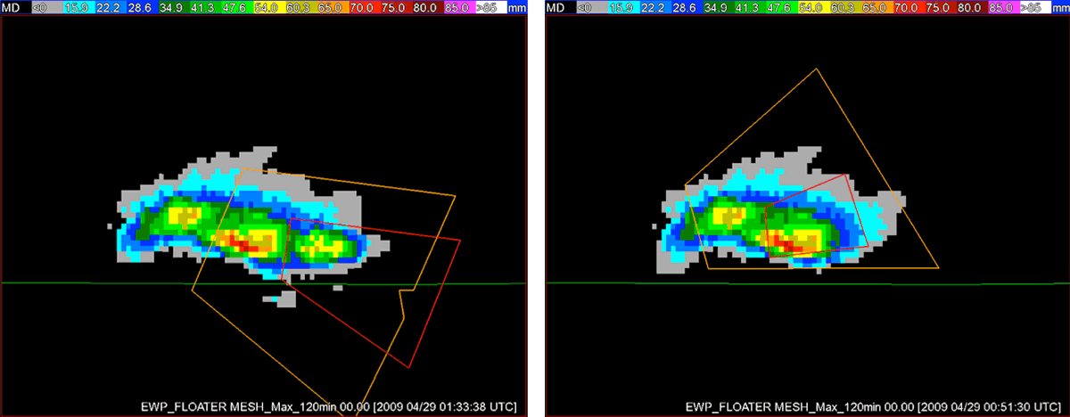
Multiple-Radar / Multiple-Sensor (MRMS) “Hail Swath” product for a supercell event in southeast New Mexico on 28 April 2009. The left figure shows the experimental warnings (orange = severe; red = tornado) issued by forecasters during real-time warning testbed operations. The right figure shows the official NWS warnings for the same event. [+]
Multiple-Radar / Multiple-Sensor (MRMS) “Hail Swath” product for a supercell event in southeast New Mexico on 28 April 2009. The left figure shows the experimental warnings (orange = severe; red = tornado) issued by forecasters during real-time warning testbed operations. The right figure shows the official NWS warnings for the same event.
Payoff
- During the interim, some of the MRMS severe weather products have been made available in an experimental data stream to the Storm Prediction Center, the NWS WFO Norman, OK, and via Google Earth.
- The MRMS system is the backbone for the NSSL On-Demand Severe Weather Verification System, by which government users, academia, and their non-commercial partners can place one-time requests for hail swath and rotation track data to aid in severe weather verification and disaster first response.
Related Publications
- Berendes, T. A., J. R. Mecikalski, W. M. MacKenzie Jr., K. M. Bedka, and U. S. Nair, 2008: Convective cloud identification and classification in daytime satellite imagery using standard deviation limited adaptive clustering. J. Geophys. Res., 113, D20207.
- Manross, K. L., T. M. Smith, J. T. Ferree, G. J. Stumpf, 2008: An on-demand user interface for requesting multi-radar, multi-sensor time accumulated products to support severe weather verification. Extended Abstracts, 23rd Conference on Interactive Information Processing Systems, New Orleans, LA, USA, AMS, P2.13.
- Ortega, K. L., 2010: Evaluating the use of reflectivity heights for hail detection with high-resolution hail reports. Extended Abstracts, 25th Conference on Severe Local Storms, Denver, CO, USA, American Meteorological Society, P4.13.