

EFP: 2009 Spring Experiment Summary
Working Hypotheses
- Numerical modelers can learn to incorporate more operational relevance in their research efforts if they work closely with forecasters in simulated operational forecasting exercises.
- Operational forecasters can make more skillful interpretations of numerical model guidance and influence the direction of model development if they work with numerical modelers in simulated operational forecasting exercises.
Specific Objectives
Research Perspective
- Evaluate sensitivities to ensemble design in the SSEF system, including number of members and diversity in dynamic core, physical parameterizations, and initial and lateral-boundary conditions.
- Expand collaborative activities with the Developmental Testbed Center to explore the utility of new objective verification measures and their relevance to ongoing subjective assessments in the Spring Forecasting Experiment.
- Evaluate the impact of different radar-data assimilation strategies for initializing convection-allowing models.
Operational Perspective
- Identify and test innovative ways to extract useful information from storm-scale deterministic and ensemble forecasting systems based on the WRF model and develop new products and display techniques that provide forecasters with meaningful probabilistic guidance on high impact convective weather events.
- Provide focused feedback to model developers on the performance of the experimental models in predictions of high impact weather.
- Explore the value of “update” WRF model runs using later initial conditions by comparing forecasts from the EMC and NCAR WRF models initialized at 00z with forecasts from the same models run at 12z. Furthermore, examine the utility of providing forecasters with convection-allowing HRRR model forecasts that are updated on an hourly basis.
Preliminary Results
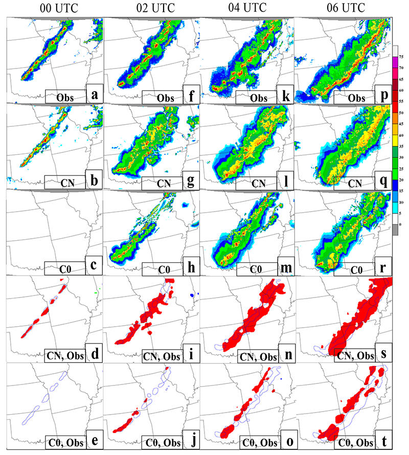
Sensitivity to radar-data assimilation: Comparison of observed and simulated composite reflectivity for forecast hours 0, 2, 4, and 6, beginning at 0000 UTC 14 May 2009. Observations are in the top row, while the CAPS control member with radar-data assimilation (CN) is in the second row and the corresponding no-assimilation member (C0) is in the third row. In the bottom two rows, the location of observed features is outlined in blue and the features predicted by the CN (fourth row) and C0 (fifth row) are overlaid and color filled. The 30 dBZ reflectivity threshold is used to define object outlines. [+]
Sensitivity to radar-data assimilation: Comparison of observed and simulated composite reflectivity for forecast hours 0, 2, 4, and 6, beginning at 0000 UTC 14 May 2009. Observations are in the top row, while the CAPS control member with radar-data assimilation (CN) is in the second row and the corresponding no-assimilation member (C0) is in the third row. In the bottom two rows, the location of observed features is outlined in blue and the features predicted by the CN (fourth row) and C0 (fifth row) are overlaid and color filled. The 30 dBZ reflectivity threshold is used to define object outlines.
- As forecast lead time increases and/or the spatial scale of predicted features decreases, more ensemble members are required to achieve a given level of skill in probabilistic forecasts of precipitation from the CAPS SSEF system.
- New sampling strategies and unique output fields from convection-allowing models show great promise for providing useful numerical guidance for storm attributes such as persistent mid-level rotation.
- Improvements in forecast skill associated with shorter-lead-time forecasts and initial-condition updates are inconsistent; updated numerical forecasts are often less skillful than previous forecasts.
- The 3DVAR data assimilation strategy used by CAPS appears to have measurable benefits on most days through at least the first 6 h of the forecast.
Payoff
- Diagnostic analysis software, designed to extract unique storm-attribute output fields from WRF-model forecasts, was implemented in SPC forecasting operations and widely adopted by operational modeling centers including NCEP/EMC and NOAA/OAR/ESRL/GSD. Furthermore, new output fields (e.g., Updraft Helicity) were adopted by the World Meteorological Organization (WMO) for standardized implementation worldwidek.
- Collaborative ties between the Hazardous Weather Testbed and Developmental Testbed Center were strengthened by the close interactions during the Spring Forecasting Experiment.
- Model developers at NCEP/EMC, CAPS, NCAR, AFWA, and elsewhere were provided valuable feedback regarding new applications of high resolution models, steering their efforts to provide better model guidance for the coming generations of operational models.
- Benchmark standards were established for assimilation of radar data in realtime, convection-allowing, CONUS-scale modeling systems.
Related Publications
- Clark, Adam J., and Coauthors, 2011: Probabilistic Precipitation Forecast Skill as a Function of Ensemble Size and Spatial Scale in a Convection-Allowing Ensemble. Mon. Wea. Rev., 139, 1410–1418.
- Coniglio, M. C., K. L. Elmore, J. S. Kain, S. J. Weiss, M. Xue, and M. L. Weisman, 2009: Evaluation of WRF model forecasts of environmental parameters for severe-weather forecasting from the NOAA HWT Spring Experiments. Preprints, 13th Conference on Mesoscale Processes, Amer. Meteor. Soc., Salt Lake City, UT, paper 5.1.
- Jensen,T.L., Brown, B.G., Nance, L., Weiss, S.J., Kain, J.S., and Coniglio, M.C., 2009: Evaluation of Experimental Forecasts from the NOAA Hazardous Weather Testbed Spring Experiment. Oral Presentation at: 23rd Conference on Weather Analysis and Forecasting, American Meteorological Society, Omaha, Nebraska, 1-5 June 2009. Not in preprints.
- Jensen,T.L., Brown, B.G., Nance, L., Weiss, S.J., Kain, J.S., and Coniglio, M.C., 2009: Evaluation of Experimental Forecasts from the 2008 and 2009 NOAA Hazardous Weather Testbed Spring Experiment. Poster Presentation at: 10th WRF Users Workshop, Boulder, Colorado, 23-26 June 2009. Not in preprints.
- Jensen, T., B. Brown, M. Coniglio, J. S. Kain, S. J. Weiss, and L. Nance, 2010a: Evaluation of experimental forecasts from the 2009 NOAA Hazardous Weather Testbed spring experiment using both traditional and spatial methods. 20th Conf. on Probability and Statistics, Atlanta, GA, Amer. Meteor. Soc., 527.
- Kain, J. S., S. J. Weiss, M. C. Coniglio, M. Xue, F. Kong, M. L. Weisman, M. E. Pyle, R. A. Sobash, C. S. Schwartz, D. R. Bright, J. J. Levit, and G. W. Carbin, 2009: New developments in applied research for severe convection forecasting in the Hazardous Weather Testbed, Norman, OK, U.S.A. Preprints, 5th European Conference on Severe Storms, European Severe Storms laboratory, Landshut, Germany, 133–134.
- Kain, J. S., S. R. Dembek, S. J. Weiss, J. L. Case, J. J. Levit, and R. A. Sobash, 2010: Extracting unique information from high resolution forecast models: Monitoring selected fields and phenomena every time step. Wea. Forecasting, 25, 1536–1542.
- Kain, J. S., M Xue, M.C. Coniglio, S. J. Weiss, F. Kong, T. L. Jensen, B. G. Brown, J. Gao, K. Brewster, K. W. Thomas, Y. Wang, C. S. Schwartz, and J. J. Levit, 2010: Assessing advances in the assimilation of radar data and other mesoscale observations within a collaborative forecasting-research environment, Wea. Forecasting, 25, 1510–1521.
- Kong, F., M. Xue, K. Thomas, Y. Wang, K. A. Brewster, J. Gao, K. K. Droegemeier, J. S. Kain, S. J. Weiss, D. R. Bright, M. C. Coniglio, and J. Du, 2009: 16A.3 A real-time storm-scale ensemble forecast system: 2009 Spring Experiment. Preprints, 23rd Conference on Weather Analysis and Forecasting/19th Conference on Numerical Weather Prediction, Amer. Meteor. Soc., Omaha, NE. paper 16A.3.
- Stratman, D. R., M. C. Coniglio, S. E. Koch, and M. Xue, 2012: Use of multiple verification methods to evaluate forecasts of convection from hot- and cold-start convection-allowing models. Weather and Forecasting, conditionally accepted.
- Xue, M., F. Kong, K. Thomas, J. Gao, Y. Wang, K. Brewster, K. Droegemeier, J. S. Kain, S. J. Weiss, D. R. Bright, M. C. Coniglio, and J. Du, 2009: CAPS realtime 4 km multi-model convection-allowing ensemble and 1 km convection-resolving forecasts for the NOAA Hazardous Weather Testbed 2009 Spring Experiment. Preprints, 23rd Conference on Weather Analysis and Forecasting/19th Conference on Numerical Weather Prediction, Amer. Meteor. Soc., Omaha, NE. paper 16A.2.