

EFP: 2008 Spring Experiment Summary
Working Hypotheses
- Numerical modelers can learn to incorporate more operational relevance in their research efforts if they work closely with forecasters in an experimental forecasting exercise.
- Operational forecasters can make more skillful interpretations of numerical model output if they work with numerical modelers in an experimental forecasting exercise.
Specific Objectives
Research Perspective
- Determine the strengths and limitations of a high-resolution ensemble forecasting system while identifying and testing innovative ways to extract useful information regarding uncertainty associated with forecasting convection.
- Examine forecasts of the pre-convective environment from convection-allowing models and compare them to forecasts from current mesoscale operational forecast models.
- Provide detailed assessments of the impact of radar-data assimilation as a function of time in 36 h convection-allowing forecasts.
Operational Perspective
- Explore new visualization strategies and techniques to provide forecasters with meaningful probabilistic guidance on high impact convective weather events, including severe convective weather, heavy rain, and aviation concerns.
- Assess the sensitivity of grid resolution in the 2-4 km range of grid spacing, particularly its impact on forecast guidance for initiation, mode and evolution of severe thunderstorms, including supercells.
- Provide focused feedback to model developers on the performance of the experimental high resolution ensemble system and deterministic models during severe thunderstorm episodes.
Preliminary Results
- Numerous strengths and weaknesses of current radar-data assimilation techniques were identified and documented
- Innovative new post-processing methods show great promise for diagnosing internal physical processes in the high resolution models and for generating probabilistic guidance based on the explicit identification of severe phenomena in output fields.
- Detailed comparison of output from experimental and operational models indicates strong agreement in terms of placement of significant features in the pre-convective environments, but much poorer correspondence in terms of the amplitude of such features.
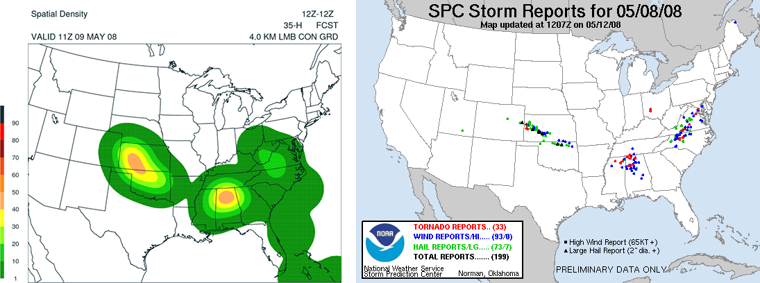
(LEFT) Experimental probabilistic severe convection forecast based on explicit identification of severe phenomena in model output, compared to (RIGHT) observed severe weather reports, valid for the 24 h period ending 1200 UTC 9 May 2008. [+]
(LEFT) Experimental probabilistic severe convection forecast based on explicit identification of severe phenomena in model output, compared to (RIGHT) observed severe weather reports, valid for the 24 h period ending 1200 UTC 9 May 2008.
Payoff
- Numerous analysis and diagnostic tools for high resolution models were developed collaboratively over the course of the experiment.
- Significant progress towards designing an optimal high-resolution ensemble; the added diversity in this year's high-resolution ensemble, in terms of both initial conditions and model physics, appears to have created a much more reliable and skillful ensemble forecast system.
- Operational model developers were provided valuable feedback regarding new applications of high resolution models, steering their efforts to provide better model guidance for the coming generations of operational models.
Related Publications
- Coniglio, M. C., K. L. Elmore, J. S. Kain, S. J. Weiss, M. Xue, and M. L. Weisman, 2010: Evaluation of WRF model output for severe-weather forecasting from the 2008 NOAA Hazardous Weather Testbed Spring Experiment. Wea. Forecasting, 25, 408–427.
- Clark, A. J., W. A. Gallus, and M. L. Weisman, 2010: Neighborhood-based verification of precipitation forecasts from convection-allowing NCAR WRF model simulations and the operational NAM. Wea. Forecasting, 25, 1495–1509.
- Kain, J. S., S. J. Weiss, S. R. Dembek, J. J. Levit, D. R. Bright, J. L. Case, M. C. Coniglio, A. R. Dean, R. A. Sobash, and C. S. Schwartz, 2008: Severe-weather forecast guidance from the first generation of large-domain convection-allowing models: Challenges and opportunities. Preprints, 24th Conference on Severe Local Storms, Amer. Meteor. Soc., Savannah, GA. CD-ROM 12.1
- Kain, J. S., M Xue, M.C. Coniglio, S. J. Weiss, F. Kong, T. L. Jensen, B. G. Brown, J. Gao, K. Brewster, K. W. Thomas, Y. Wang, C. S. Schwartz, and J. J. Levit, 2010b: Assessing advances in the assimilation of radar data and other mesoscale observations within a collaborative forecasting-research environment, Wea. Forecasting, 25, 1510-1521.
- Kong, F, M. Xue, K. K. Droegemeier, K. W. Thomas, Y. Wang, J. S. Kain, S. J. Weiss, D. R. Bright, and J. Du, 2008: Real-time stormscale ensemble forecast 2008 Spring Experiment. Preprints, 24th Conference on Severe Local Storms, Amer. Meteor. Soc., Savannah, GA. CD-ROM 12.3.
- Sobash, R. A., D. R. Bright, A. R. Dean, J. S. Kain, M. Coniglio, S. J. Weiss, and J. J. Levit, 2008: Severe storm forecast guidance based on explicit identification of convective phenomena in WRF-model forecasts. Preprints, 24th Conference on Severe Local Storms, Amer. Meteor. Soc., Savannah, GA. CD-ROM 11.3.
- Sobash, R A., J. S. Kain, D. R. Bright, A. R. Dean, M. C. Coniglio, and S. J. Weiss, 2011: Probabilistic forecast guidance for severe thunderstorms based on the identification of extreme phenomena in convection-allowing model forecasts. Wea. Forecasting, 26, 714-728.
- Xue, M., F. Kong, K. W. Thomas, J. Gao, Y. Wang, K. Brewster, K. K. Droegemeier, J. S. Kain, S. J. Weiss, D. R. Bright, M. C. Coniglio, and J. Du, 2008: CAPS realtime storm-scale ensemble and high-resolution forecasts as part of the NOAA Hazardous Weather Testbed 2008 Spring Experiment. Preprints, 24th Conference on Severe Local Storms, Amer. Meteor. Soc., Savannah, GA. CD-ROM 12.2